


Les Granges par Grusse

drarep
User
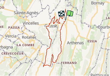

Length
17.5 km

Max alt
554 m

Uphill gradient
597 m
Km-Effort
25 km

Min alt
232 m

Downhill gradient
599 m
Boucle
Yes
Creation date :
2019-11-28 10:20:51.95
Updated on :
2019-12-22 09:21:49.902
5h19
Difficulty : Medium

FREE GPS app for hiking
 SityTrail
IGN / Geographical institutes
SityTrail Plus
The world is yours!
About
Trail Walking of 17.5 km to be discovered at Bourgogne-Franche-Comté, Jura, La Chailleuse. This trail is proposed by drarep.
Positioning
Country:
France
Region :
Bourgogne-Franche-Comté
Department/Province :
Jura
Municipality :
La Chailleuse
Location:
Saint-Laurent-la-Roche
Start:(Dec)
Start:(UTM)
692936 ; 5164040 (31T) N.
Comments